
Major Navigator CS LLC News
FAA’s Part 107 Rules Ease Some of the Challenges Faced by Commercial UAS Operators – December 13, 2016

Navigator CS recently Published in Earth Imaging Journal Web.
Navigator CS, LLC enhances its UAS aerial surveying and photogrammetry capabilities – April 4, 2016
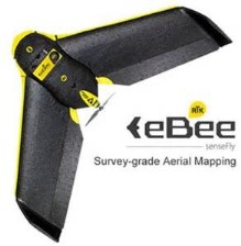
Navigator CS, LLC and its business partner Rice Associates, Inc. recently acquired a senseFly eBee RTK Unmanned Aircraft System (UAS), commonly known as a “drone,” to enhance their surveying and photogrammetry capabilities. “The eBee RTK is senseFly’s survey-grade mapping drone,” said Charlie Rice, Past President and Corporate Quality Control Manager of Rice Associates, Inc. “For specific projects the need for ground control targets can be reduced. And, depending upon the project requirements, may be removed altogether. ” These innovations include the use of a built-in RTK-capable Global Navigation Satellite System (GNSS) antenna, and the use of senseFly’s eMotion and PostFlight Terra 3D (powered by Pix4D) software to plan the mission and process the aerial images, respectively. “The post-processing software we use can produce high accuracy point clouds, DSMs and orthomosaics,” said Rice.
“We are excited about the capabilities this fixed-wing unmanned aircraft has to offer,” said Paul Beckwith, President of Navigator CS, LLC. “The aircraft can cover an area of 3 square miles on a single battery charge and we can plan missions over much larger areas that can flow seamlessly across multiple independent flights. These features make the eBee RTK the unmanned aircraft of choice for projects that require surface area coverage larger than can be covered by other UAS platforms with shorter flight times.” As co-owners of the eBee RTK, both companies will explore opportunities to expand the use of the unit, for which Navigator CS will be the primary pilot. In anticipation of the acquisition of this technology, Navigator CS submitted a petition to the FAA in November 2015 requesting an expansion of their Section 333 Exemption to add other UAS technologies, including the senseFly eBee RTK. “Our current quadcopters are excellent for vertical flights that require hovering-in-place capability, pictures of vertical surfaces, and development of point clouds of buildings and other structures,” added Beckwith, “but the quadcopters have shorter flight times and consequently cover smaller areas. Each aircraft has its niche and we are very excited about adding the capability to fly close to 40 minutes on a single battery charge and cover such large areas.”
Since announcing their business partnership last year, Rice Associates and Navigator CS have been performing proof-of-concept flights and obtaining aerial images in support of surveying and mapping projects, especially in applications where the operational features of drones have made them the technology of choice. “According to senseFly, the eBee RTK can achieve 3 cm horizontal and 5 cm vertical accuracy with an expected level of accuracy of between one to three times ground sampling distance,” said Rice. “Together with Navigator CS, we will endeavor to validate these claims utilizing data obtained previously by conventional methods.”
Navigator CS, LLC showcases its Unmanned Aerial Services at Esri’s 2016 FedGIS Conference – February 24 – 25, 2016
Navigator’s President, Paul Beckwith, and Sr. Project Engineer, Gladys Miller, manned a booth within Esri’s Unmanned Aircraft Systems (UAS) Neighborhood during Esri’s 2016 FedGIS Conference at the Walter E. Washington Convention Center in Washington, DC. Navigator also gave UAS demonstration flights inside a UAS Cage and delivered a presentation titled “UAS Imaging Services: Buyers Beware!” The talk aimed to educate buyers of UAS services on existing laws and regulations applicable to UAS operators, and provided a checklist to aide buyers with the selection of providers of civil/commercial UAS services, and to ensure that the flights are within the law.
Esri’s technology helps virtually every federal agency meet its mission, from providing health care and emergency services to managing facilities and natural resources. As the largest geospatial technology event for federal agencies, Esri’s FedGIS Conference brings together over 3,000 attendees for two days of intensive training and networking.
Navigator CS, LLC to use its UAS aerial imaging projects to beta test Esri’s Drone2Map for ArcGIS software – February 19, 2015
Esri’s Drone2Map for ArcGIS turns raw still images from drones into professional 2D and 3D products such as orthomosaics, digital surface models, and 3D point clouds and meshes. The app detects camera and sensor parameters and then intelligently applies appropriate defaults, thus making affordable imagery available on demand for land analysis, infrastructure inspection, and monitoring events such as natural disasters and environmental changes.
In the field, Drone2Map for ArcGIS offers rapid image processing, so users like Navigator can make sure we’ve captured everything we need right away, avoiding costly return trips. The images can be used immediately in ArcGIS to provide a clear, accurate picture of any asset or area for mapping, analysis, and decision making. The photogrammetry engine in Drone2Map for ArcGIS is powered by Pix4D, an industry leader in professional image processing software. Navigator will beta test the app and will provide feedback to Esri in anticipation of the app’s release to the public this summer.
Navigator assisted Esri with the development of the Drone2Map application by working closely with Esri’s product development team and flying imagery collection missions for both still picture and video. The pictures, video, and corresponding data have been used by Esri in product testing, marketing and development of sample data, which is included with the app. Check out the Drone2Map app atwww.esri.com/drone2map.
FAA proposes civil penalties against unauthorized UAS aerial photography operations – October 6, 2015
The FAA proposed a $1.9 million civil penalty against an unmanned aircraft systems (UAS) operator for allegedly conducting unauthorized commercial aerial photography operations over various locations in New York City and Chicago. “Flying unmanned aircraft in violation of the Federal Aviation Regulations is illegal and can be dangerous,” said FAA Administrator Michael Huerta. “We have the safest airspace in the world, and everyone who uses it must understand and observe our comprehensive set of rules and regulations.” To read the Press Release, go to http://www.faa.gov/news/press_releases/news_story.cfm?newsId=19555.
Navigator CS, LLC is helping UAS operators ensure that their operations are legal and safe, by preparing and filing their petitions for exemption and supporting the development of the infrastructure required to comply with the Conditions and Limitations of their granted exemptions.
Navigator CS, LLC to utilize its UAS aerial imaging projects to beta test FAA’s B4UFLY application – August 28, 2015
Navigator CS, LLC has been selected by the FAA to participate in the beta test of the B4UFLY application for iOS devices, to support unmanned aircraft systems (UAS) operations. The FAA’s smartphone app may be used by unmanned aircraft operators to determine if there are any restrictions or requirements in effect at the location where they want to fly. B4UFLY’s primary purpose is to promote safety and to increase situational awareness. The FAA expects the beta test will yield valuable data on how well B4UFLY functions, as well as uncovering any software bugs. The beta test is expected to run for several months, after which the FAA plans to make B4UFLY available to the general public.
Navigator CS, LLC’s new business partnership expands its UAS surveying and photogrammetry capabilities – August 4, 2015
Rice Associates, Inc. and Navigator CS, LLC have announced the formation of a business partnership that will allow Rice Associates to utilize Navigator’s Unmanned Aircraft Systems (UAS), commonly known as “drones,” to enhance its surveying and photogrammetry capabilities. By teaming up with Navigator CS, Rice Associates will be able to safely, quickly, efficiently, and economically obtain aerial imaging that supports their surveying and mapping projects, especially in applications where the operational features of drones make them the technology of choice. Rice Associates is a geospatial services firm providing in-house photogrammetry, LiDAR scanning, building information modeling, conventional surveying and subsurface utility designation and mapping. The firm, headquartered in Manassas, Virginia, was founded in 1986 and maintains branch offices in Richmond and Virginia Beach. The firm offers a broad range of surveying and mapping services to a diverse base of public and private clients.
Navigator CS, LLC’s UAS support Esri’s development of software to process UAS aerial images; Navigator welcomed into Esri’s Partner Network – July 28, 2015
Navigator CS, LLC was welcomed into Esri’s Partner Network, a worldwide community of companies developing and delivering cutting-edge geospatial solutions and services based on Esri’s technology. Navigator CS used its Unmanned Aircraft Systems (UAS), commonly known as “drones,” to assist Esri with the development of software capability to quickly process aerial imaging obtained from UAS into high quality GIS maps and point clouds. We also provided aerial imaging for several of Esri’s presentations at their 2015 User Conference (see http://video.esri.com/watch/4652/unmanned-aerial-systems). Navigator CS, LLC worked closely with Esri during all planning efforts and carried out our work in a highly professional manner. Navigator CS is not currently an Esri Partner
Navigator CS, LLC granted Section 333 Exemption to operate UAS for civil/commercial operations – May 22, 2015
The U.S. Department of Transportation’s Federal Aviation Administration (FAA) granted Navigator CS, LLC’s petition for exemption to operate Unmanned Aircraft Systems (UAS), commonly known as “drones,” to obtain aerial imaging in support of engineering surveys of construction sites, existing buildings and facilities, and other sites, for the purpose of monitoring and ensuring site safety, proper material usage, quality of workmanship, and/or to inspect the integrity of buildings and/or structures, including bridges and dams.