
Navigator CS, LLC and Rice Associates, Inc. enhance their UAS Photogrammetry Capabilities
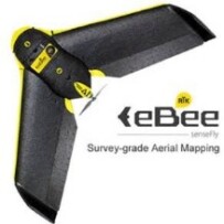
Navigator CS, LLC and its business partner Rice Associates, Inc. recently acquired a senseFly eBee RTK Unmanned Aircraft System (UAS), commonly known as a “drone,” to enhance their surveying and photogrammetry capabilities. “The eBee RTK is senseFly’s survey-grade mapping drone,” said Charlie Rice, Past President and Corporate Quality Control Manager of Rice Associates, Inc. “For specific projects the need for ground control targets can be reduced. And, depending upon the project requirements, may be removed altogether. ” These innovations include the use of a built-in RTK-capable Global Navigation Satellite System (GNSS) antenna, and the use of senseFly’s eMotion and PostFlight Terra 3D (powered by Pix4D) software to plan the mission and process the aerial images, respectively. “The post-processing software we use can produce high accuracy point clouds, DSMs and orthomosaics,” said Rice.
“We are excited about the capabilities this fixed-wing unmanned aircraft has to offer,” said Paul Beckwith, President of Navigator CS, LLC. “The aircraft can cover an area of 3 square miles on a single battery charge and we can plan missions over much larger areas that can flow seamlessly across multiple independent flights. These features make the eBee RTK the unmanned aircraft of choice for projects that require surface area coverage larger than can be covered by other UAS platforms with shorter flight times.” As co-owners of the eBee RTK, both companies will explore opportunities to expand the use of the unit, for which Navigator CS will be the primary pilot. In anticipation of the acquisition of this technology, Navigator CS submitted a petition to the FAA in November 2015 requesting an expansion of their Section 333 Exemption to add other UAS technologies, including the senseFly eBee RTK. “Our current quadcopters are excellent for vertical flights that require hovering-in-place capability, pictures of vertical surfaces, and development of point clouds of buildings and other structures,” added Beckwith, “but the quadcopters have shorter flight times and consequently cover smaller areas. Each aircraft has its niche and we are very excited about adding the capability to fly close to 40 minutes on a single battery charge and cover such large areas.”
Since announcing their business partnership last year, Rice Associates and Navigator CS have been performing proof-of-concept flights and obtaining aerial images in support of surveying and mapping projects, especially in applications where the operational features of drones have made them the technology of choice. “According to senseFly, the eBee RTK can achieve 3 cm horizontal and 5 cm vertical accuracy with an expected level of accuracy of between one to three times ground sampling distance,” said Rice. “Together with Navigator CS, we will endeavor to validate these claims utilizing data obtained previously by conventional methods.”